


![Kansas City Chiefs Have Taylor Swift, Here Is Every NFL Team’s Celebrity Muse [Part 1]](https://thechive.com/wp-content/uploads/2025/08/lead_e9029f.jpg?attachment_cache_bust=5072647&quality=85&strip=info#)


Hurricane Erin could form this weekend: Maps and live tools track the tropical storm’s path as it heads toward the U.S. coast
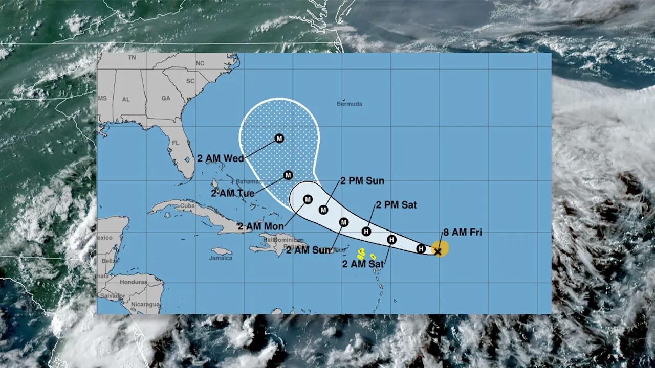
The first Atlantic hurricane of the year could be upon us. Right now, Tropical Storm Erin is making its way through the tropical Atlantic, where it is currently to the east of several Caribbean nations, including Dominica and St Lucia.
But as the storm continues to move west-northwest towards the continental United States, it is expected to strengthen, potentially becoming a Category 4 hurricane. Here’s what you need to know about the first possible Atlantic hurricane of the year, and the maps you can view to track its path.
Will Tropical Storm Erin become a hurricane?
It’s likely Tropical Storm Erin will become a hurricane however, that outcome cannot be guaranteed. According to a recent bulletin from the National Hurricane Center in Miami, as of Friday, Erin is on track to become a hurricane.
“Maximum sustained winds are near 70 mph (110 km/h) with higher gusts,” the bulletin states. “Steady strengthening is expected during the next few days and Erin is forecast to become a hurricane later today, and it could become a major hurricane by this weekend.”
As of 5:00 AM AST Friday morning, the National Hurricane Center (NHC), a division of the National Oceanic and Atmospheric Administration, cautions that heavy rain is expected “across the northernmost Leeward Islands, the U.S. and British Virgin Islands, as well as southern and eastern Puerto Rico.” The agency says the rains “may lead to isolated flash and urban flooding, along with landslides or mudslides this weekend into early next week.”
However, even though the storm is still growing while it’s moving west-northwest, the National Hurricane Center is uncertain whether Erin, even if it becomes a hurricane, will make landfall in the Caribbean or on the East Coast of the United States.
Yet the agency cautions that even if Erin doesn’t make landfall, the force still poses a threat.
“While there is still uncertainty in what impacts might occur in portions of the Bahamas, the east coast of the United States, and Bermuda next week, the risk of dangerous surf and rip currents across the western Atlantic basin next week continues to increase,” the NHC says.
Use these maps to track Tropical Storm Erin
Those who want to track the storm’s progress can do so by viewing a number of maps the National Hurricane Center regularly updates. Those maps include:
- The Seven-Day Graphical Tropical Weather Outlook
- The Tropical Storm Erin interactive map
- A map that shows the Earliest Reasonable Arrival Time of Tropical-Storm-Force Winds
- A map that displays the Coastal Watches/Warnings and Forecast Cone for Storm Center
These maps are regularly updated, so if you want to track the storm throughout the weekend, you should check back on them often.
Erin isn’t the only hurricane to look out for
If Erin does become a hurricane, it will only be the first of many that the Atlantic is expected to bear this year.
In an August 7 post, the National Oceanic and Atmospheric Administration (NOAA) said that there will be between five and nine hurricanes this season, and between two and five of those hurricanes will be “major.”
In addition to the hurricanes, this season is expected to experience an additional 13-18 named storms.
What's Your Reaction?
 Like
0
Like
0
 Dislike
0
Dislike
0
 Love
0
Love
0
 Funny
0
Funny
0
 Angry
0
Angry
0
 Sad
0
Sad
0
 Wow
0
Wow
0