


![Walter Boys Season 2 Finale Delivers Not One, But Two Cliffhangers — Is [Spoiler] Dead?](https://tvline.com/wp-content/uploads/2025/08/my-life-of-the-wlater-boys-season-2-finale_33d3b0.jpg?#)


The world is melting. This shade map is the only thing that can save us
The sun is liquifying Madrid. Again.
June 2025 shattered temperature records, with Spain recording its hottest June since weather records began in 1961. The month averaged 74.5°F, with a peak temperature of 114.8°F in El Granado, Huelva, while the Spanish capital experienced temperatures as high as 102°F. Now another heat wave is coming that will easily beat 40ºC, which I believe is equivalent to ‘lava’ in Fahrenheit.
I shouldn’t have been surprised to discovered that, of course, there’s an app for that: One that makes summer urban wandering a bit less dangerous by telling you which streets have more shade in a city at any given time.
Usually, reasonable people would stay at home, but Spaniards being Spaniards, the ‘Call of the Terrace’ is too strong to resist. Our nature is weak even in the face of a deluge of deadly photons from our home star. We are like water buffalos herding towards the water knowing that death by crocodile awaits. It doesn’t matter: ‘Cañas’—the deliciously cold foamy tap beer served in very small glasses that you must drink before you die—‘tapas’, and messing around with friends in a shady terrace is all that counts.
That’s why yesterday a friend shared a tweet that said “Google Maps is taking too long to include the option of how to get there but ‘por la sombra.’” That’s an idiom that literally means “through the shade” and figuratively means to be careful and protect yourself, which you really need to do here during the summer (more than a thousand deaths attributed to heat waves in the last two months, the government says). I thought the idea of a navigation app to show you routes through streets with the most shade was a clever idea. After all, I’ve been playing that game with my son walking these past few weeks, back and forth to the summer camp bus, triangulating in our heads the optimal street walking sequence to avoid this ultraviolet tsunami.
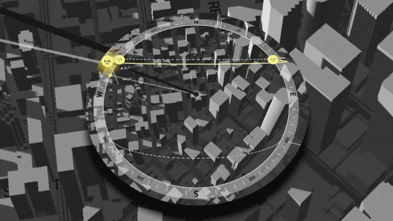
That’s when another friend chimed in with a solution: “I have become addicted to this website. Photography directors use to see if a location is in the sun or in the shade. It’s a ‘Google Maps of shade’.” He then pasted a link to something called Shademap.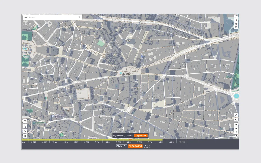
It was cool: A 3D map that could put you anywhere in the world to visually show the buildings’ shadows on the street at any time and any day, for free. For a bit of money you can also see the shade projected by terrain and actual trees captured with aerial LiDAR, the laser sensor that creates three-dimensional maps of the world. The Shademap interface has a search bar on the top to find a location, which you can adjust using the same mouse conventions of Google Maps. A bar on the bottom allows you to easily select the date and time, which you can animate just by scrubbing a timeline. Seeing the shadows change throughout the day is surprisingly fun. You should try it.
Sunlight is everything
Shademap exists because life and every significant decision related to the design of our environment comes down to the sun. Homeowners planning a house extension may need to know how their addition will affect their neighbor’s garden or their own. Real estate buyers want to understand whether that cool Manhattan duplex with a glass rooftop will become a radioactive death chamber by July. Landscape designers must predict which plants will thrive and which will wither on a certain spot based on seasonal sun exposure. Architects use it to position windows that maximize winter warmth while minimizing summer heat. Urban planners rely on shadow analysis to design parks and public infrastructure that people can enjoy.
Solar power installers calculate optimal placement sites and angles in a house or a factory to maximize energy capture. The latter is especially important as the world moves away from fossil fuels: Knowing the solar energy potential for any location is what allows engineers to design massive solar farms. And there’s the film and leisure aspect that I already mentioned. Shademap is the kind of tool that makes you realize how much of our world depends on understanding a single, predictable celestial body that we regular peeps largely ignore until it’s trying to kill us.
In my quest to find a dedicated shaded terrace locator, I also found an alternative to Shademap called Shadowmap, a professional tool which a more polished interface that offers a lot more features than Shademap. It’s divided in three tiers. You can use it for free, too, which provides basic functionality including sun path visualization, current-day time changes, and worldwide 3D buildings and terrain. 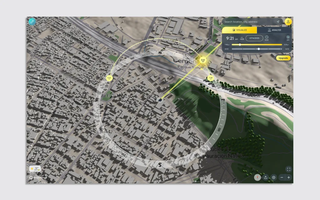
Shadowmap Explorer ($2.50/month) adds full camera freedom and first-person view, making it ideal for photographers, film crews, and event planners, or dedicated hikers (the antithesis of the Spanish terrace buffalo). Shadowmap Home ($8.33/month) includes all Explorer features plus high-quality 3D buildings, satellite maps, enhanced rendering options, and global weather/UV forecasts—designed for homeowners, gardeners, and property seekers who want to really look at how a new home will get illuminated throughout the year. For professionals, there’s Shadowmap Studio ($58/month annually), which includes everything plus the ability to upload custom 3D models of your own projects, interactive solar analytics, project sharing capabilities, and Google’s high-resolution satellite imagery. This tier is specifically designed for architects, urban planners, real estate professionals, and solar energy specialists who need advanced modeling capabilities.
Which, OK, whatever, cool I guess. The question remains, “Where can I have a caña and eat half a dozen gildas without melting into the sidewalk?” That’s the tier I’m missing, Shadowmap, Shademap, Google, and whomever in hell is reading this. Make it a phone app, too, so I can search directly for “terraces in the shade near me RIGHT NOW!!” It will kill it in Spain—and the rest of the world—I tell you.
(But only Spain gets the jamón ibérico and boquerones lubricated with vermouth.)
What's Your Reaction?
 Like
0
Like
0
 Dislike
0
Dislike
0
 Love
0
Love
0
 Funny
0
Funny
0
 Angry
0
Angry
0
 Sad
0
Sad
0
 Wow
0
Wow
0


